![](/images/other/stat-length.png)
![Tocht Stappen Lucé - À partir de la maison - Photo](https://media.geolcdn.com/t/1900/400/ext.pjpeg?maxdim=2&url=https%3A%2F%2Fstatic1.geolcdn.com%2Fsiteimages%2Fupload%2Ffiles%2F1553511878bg_sport_marche.png)
À partir de la maison
ezola
Gebruiker
![Lengte](/images/other/stat-length.png)
Lengte
17,7 km
![Boucle](https://static1.geolcdn.com/siteimages/upload/files/16400158638029165_repeat_loop_refresh_sync_direction_icon.png)
Boucle
Ja
Datum van aanmaak :
2019-07-24 07:21:36.0
Laatste wijziging :
2019-07-24 11:15:31.532
![Stappen](https://static1.geolcdn.com/sitytour/trail-icons/101.png)
3h36
Moeilijkheid : Medium
![Scan deze QR-code om de tocht te openen in de SityTrail-applicatie](https://capi.geolives.com/qq0zvz2zws4bq2lad0pu/sitytour/trails/2149232/qr.png?size=200)
Gratisgps-wandelapplicatie
Over ons
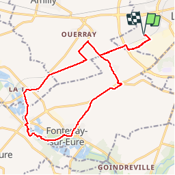
Tocht Stappen van 17,7 km beschikbaar op Centre-Val de Loire, Eure-et-Loir, Lucé. Deze tocht wordt voorgesteld door ezola.
Beschrijving
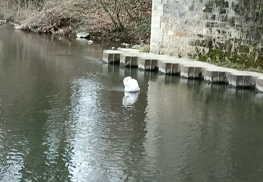
Éviter de tout prendre la route tout de suite après bouquet d’arbres direction ouatât
Plaatsbepaling
Land:
France
Regio :
Centre-Val de Loire
Departement/Provincie :
Eure-et-Loir
Gemeente :
Lucé
Locatie:
Unknown
Vertrek:(Dec)
Vertrek:(UTM)
384873 ; 5365255 (31U) N.
Opmerkingen
Wandeltochten in de omgeving
![Tocht Stappen Chartres - balade autour cathédrale de Chartres - Photo](https://media.geolcdn.com/t/375/260/ext.jpg?maxdim=2&url=https%3A%2F%2Fmedia.geolcdn.com%2Ff%2F589e1a6c-9aee-41e4-b0c1-21e1dc04e42e.jpg)
![Stappen Stappen](https://static1.geolcdn.com/sitytour/trail-icons/101.png)
balade autour cathédrale de Chartres
Stappen
Gemakkelijk
Chartres,
Centre-Val de Loire,
Eure-et-Loir,
France
![](/images/other/stat-length.png)
5,3 km | 6,1 km-effort
2h 31min
![](https://static1.geolcdn.com/siteimages/upload/files/16400158638029165_repeat_loop_refresh_sync_direction_icon.png)
Ja
![Tocht Mountainbike Mainvilliers - Les planeurs de la base des planeurs d''Armenonville - Chartres - Photo](https://media.geolcdn.com/t/375/260/ext.jpg?maxdim=2&url=https%3A%2F%2Fservices.sitytrail.com%2FGeolivesWS%2FDownloadMedia.ashx%3FTrailID%3D172818%26Media%3D14251_6.jpg)
![Mountainbike Mountainbike](https://static1.geolcdn.com/sitytour/trail-icons/202.png)
Les planeurs de la base des planeurs d''Armenonville - Chartres
Mountainbike
Medium
(1)
Mainvilliers,
Centre-Val de Loire,
Eure-et-Loir,
France
![](/images/other/stat-length.png)
53 km | 60 km-effort
4h 0min
![](https://static1.geolcdn.com/siteimages/upload/files/16400158638029165_repeat_loop_refresh_sync_direction_icon.png)
Ja
![Tocht Stappen Chartres - 2023 Chartres tour de ville - Photo](https://media.geolcdn.com/t/375/260/ext.jpg?maxdim=2&url=https%3A%2F%2Fmedia.geolcdn.com%2Ff%2Fdc0d9c93-9da7-45cc-94c6-fd51d08d97c6.jpg)
![Stappen Stappen](https://static1.geolcdn.com/sitytour/trail-icons/101.png)
2023 Chartres tour de ville
Stappen
Gemakkelijk
Chartres,
Centre-Val de Loire,
Eure-et-Loir,
France
![](/images/other/stat-length.png)
11,3 km | 12,4 km-effort
1h 58min
![](https://static1.geolcdn.com/siteimages/upload/files/16400158638029165_repeat_loop_refresh_sync_direction_icon.png)
Ja
![Tocht Stappen Luisant - 2023 poney club Luisant - Photo](https://media.geolcdn.com/t/375/260/ext.jpg?maxdim=2&url=https%3A%2F%2Fmedia.geolcdn.com%2Ff%2Ff79cf83c-4943-43a3-b8fd-6c24cb55f677.jpg)
![Stappen Stappen](https://static1.geolcdn.com/sitytour/trail-icons/101.png)
2023 poney club Luisant
Stappen
Moeilijk
Luisant,
Centre-Val de Loire,
Eure-et-Loir,
France
![](/images/other/stat-length.png)
10,8 km | 12,3 km-effort
2h 48min
![](https://static1.geolcdn.com/siteimages/upload/files/16400158638029165_repeat_loop_refresh_sync_direction_icon.png)
Ja
![Tocht Noords wandelen Chartres - Chartres Stade GP vers St prest - Photo](https://media.geolcdn.com/t/375/260/ext.jpg?maxdim=2&url=https%3A%2F%2Fmedia.geolcdn.com%2Ff%2F38bd2996-8114-4e41-ad68-81ce046a739f.jpg)
![Noords wandelen Noords wandelen](https://static1.geolcdn.com/sitytour/trail-icons/102.png)
Chartres Stade GP vers St prest
Noords wandelen
Gemakkelijk
Chartres,
Centre-Val de Loire,
Eure-et-Loir,
France
![](/images/other/stat-length.png)
12,9 km | 14,4 km-effort
2h 27min
![](https://static1.geolcdn.com/siteimages/upload/files/16400158638029165_repeat_loop_refresh_sync_direction_icon.png)
Ja
![Tocht Noords wandelen Fontenay-sur-Eure - Fontenay sur Eure - Photo](https://media.geolcdn.com/t/375/260/ext.jpg?maxdim=2&url=https%3A%2F%2Fmedia.geolcdn.com%2Ff%2Ffbe934a9-a5ea-403c-93f0-657ce0a621c8.jpg)
![Noords wandelen Noords wandelen](https://static1.geolcdn.com/sitytour/trail-icons/102.png)
Fontenay sur Eure
Noords wandelen
Medium
Fontenay-sur-Eure,
Centre-Val de Loire,
Eure-et-Loir,
France
![](/images/other/stat-length.png)
10,9 km | 12,3 km-effort
2h 9min
![](https://static1.geolcdn.com/siteimages/upload/files/16400158638029165_repeat_loop_refresh_sync_direction_icon.png)
Ja
![Tocht Noords wandelen Luisant - Le Carillon Luisant - Photo](https://media.geolcdn.com/t/375/260/ext.jpg?maxdim=2&url=https%3A%2F%2Fmedia.geolcdn.com%2Ff%2F711a0c9b-4eb0-4d41-81e2-420b0ecb901d.jpg)
![Noords wandelen Noords wandelen](https://static1.geolcdn.com/sitytour/trail-icons/102.png)
Le Carillon Luisant
Noords wandelen
Medium
Luisant,
Centre-Val de Loire,
Eure-et-Loir,
France
![](/images/other/stat-length.png)
11,9 km | 13,5 km-effort
2h 2min
![](https://static1.geolcdn.com/siteimages/upload/files/16400158638029165_repeat_loop_refresh_sync_direction_icon.png)
Ja
![Tocht Stappen Chartres - Le tour de Chartres - Photo](https://media.geolcdn.com/t/375/260/ext.jpg?maxdim=2&url=https%3A%2F%2Fmedia.geolcdn.com%2Ff%2F09d0a82b-a8be-4e4f-9fca-c4af537351a5.jpg)
![Stappen Stappen](https://static1.geolcdn.com/sitytour/trail-icons/101.png)
Le tour de Chartres
Stappen
Gemakkelijk
Chartres,
Centre-Val de Loire,
Eure-et-Loir,
France
![](/images/other/stat-length.png)
11,6 km | 12,9 km-effort
2h 20min
![](https://static1.geolcdn.com/siteimages/upload/files/16400158638029165_repeat_loop_refresh_sync_direction_icon.png)
Ja
![Tocht Noords wandelen Chartres - Pl.Drouaise - Photo](https://media.geolcdn.com/t/375/260/ext.jpg?maxdim=2&url=https%3A%2F%2Fmedia.geolcdn.com%2Ff%2F9a782b84-d1d8-4a07-b1f4-c2cbc8c766a4.jpg)
![Noords wandelen Noords wandelen](https://static1.geolcdn.com/sitytour/trail-icons/102.png)
Pl.Drouaise
Noords wandelen
Gemakkelijk
Chartres,
Centre-Val de Loire,
Eure-et-Loir,
France
![](/images/other/stat-length.png)
10,1 km | 11,2 km-effort
1h 49min
![](https://static1.geolcdn.com/siteimages/upload/files/16400158638029165_repeat_loop_refresh_sync_direction_icon.png)
Ja