


chavaroche

bouscaillou
Gebruiker
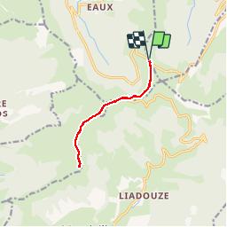

Lengte
10,5 km

Max. hoogte
1729 m

Positief hoogteverschil
516 m
Km-Effort
17,4 km

Min. hoogte
1512 m

Negatief hoogteverschil
513 m
Boucle
Ja
Datum van aanmaak :
2019-07-18 07:34:56.684
Laatste wijziging :
2019-08-03 10:46:10.696
5h00
Moeilijkheid : Medium

Gratisgps-wandelapplicatie
 SityTrail
IGN / Geografische instituten
SityTrail Plus
De wereld gaat voor u open
Over ons
Tocht Stappen van 10,5 km beschikbaar op Auvergne-Rhône-Alpes, Cantal, Le Falgoux. Deze tocht wordt voorgesteld door bouscaillou.
Plaatsbepaling
Land:
France
Regio :
Auvergne-Rhône-Alpes
Departement/Provincie :
Cantal
Gemeente :
Le Falgoux
Locatie:
Unknown
Vertrek:(Dec)
Vertrek:(UTM)
474121 ; 4995760 (31T) N.
Opmerkingen