


Moutiers au Perche 06.82

togolo28
Gebruiker
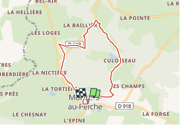

Lengte
6,9 km

Max. hoogte
208 m

Positief hoogteverschil
131 m
Km-Effort
8,7 km

Min. hoogte
158 m

Negatief hoogteverschil
135 m
Boucle
Ja
Datum van aanmaak :
2014-12-10 00:00:00.0
Laatste wijziging :
2020-02-22 13:29:38.791
1h51
Moeilijkheid : Gemakkelijk

Gratisgps-wandelapplicatie
 SityTrail
IGN / Geografische instituten
SityTrail Plus
De wereld gaat voor u open
Over ons
Tocht Stappen van 6,9 km beschikbaar op Normandië, Orne, Moutiers-au-Perche. Deze tocht wordt voorgesteld door togolo28.
Plaatsbepaling
Land:
France
Regio :
Normandië
Departement/Provincie :
Orne
Gemeente :
Moutiers-au-Perche
Locatie:
Unknown
Vertrek:(Dec)
Vertrek:(UTM)
340868 ; 5371485 (31U) N.
Opmerkingen