Tocht  Arvieux - Le Pic des Esparges Fines - Photo
 cherlieu
cherlieu

Gebruiker

© OpenStreetMap contributors
Lengte
Lengte
17,5 km
Max. hoogte
Max. hoogte
2680 m
Positief hoogteverschil
1134 m
Km-Effort
Km-Effort  
33 km
Min. hoogte
Min. hoogte
1732 m
Negatief hoogteverschil
1134 m
Boucle
Boucle
Ja
Datum van aanmaak :
2019-08-24 19:55:30.951
Laatste wijziging :
2019-08-24 19:55:30.951

(0 Bericht)


Scan deze QR-code om de tocht te openen in de SityTrail-applicatie

Gratisgps-wandelapplicatie

Logo SityTrail SityTrail

IGN / Geografische instituten

SityTrail uit de App Store downloaden SityTrail uit Google Play downloaden

Logo SityTrail SityTrail Plus

De wereld gaat voor u open

SityTrail uit de App Store downloaden SityTrail uit Google Play downloaden SityTrail op Huawei AppGallery downloaden

Over ons

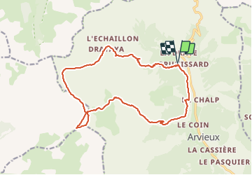
Tocht van 17,5 km beschikbaar op Provence-Alpes-Côte d'Azur, Hautes-Alpes, Arvieux. Deze tocht wordt voorgesteld door cherlieu.

Hoogteprofiel

POI's

POI Arvieux - Parking - Photo
cherlieu
ARVIEUX 
POI Arvieux - Torrent de Combe Bonne - Photo
cherlieu
POI Arvieux - Cabane de la Gardère - Photo
cherlieu
POI Arvieux - Lac du Lauzon - Photo
cherlieu
ARVIEUX 
POI La Roche-de-Rame - Col du Lauzon - Photo
cherlieu
LA ROCHE-DE-RAME 
POI Arvieux - Pic des Esparges Fines - Photo
cherlieu
POI La Roche-de-Rame - Col du Givre, virer à droite - Photo
cherlieu
POI La Roche-de-Rame - Col de Néal - Photo
cherlieu
LA ROCHE-DE-RAME 
POI Arvieux - Chalets de Clapeyto - Photo
cherlieu
POI Arvieux - À droite sur le sentier - Photo
cherlieu
POI Arvieux - Le Collet Haut - Photo
cherlieu
POI Arvieux - Col du Cros - Photo
cherlieu
ARVIEUX 
POI Arvieux - Bois Bernard, tout droit - Photo
cherlieu
POI Arvieux - Parking - Photo
cherlieu
ARVIEUX 

Plaatsbepaling

Land:
France
Regio :
Provence-Alpes-Côte d'Azur
Departement/Provincie :
Hautes-Alpes
Gemeente :
Arvieux
Locatie:
Unknown
Vertrek:(UTM)
320191 ; 4962551 (32T) N.


Sluiten
Mijn abonnementen