


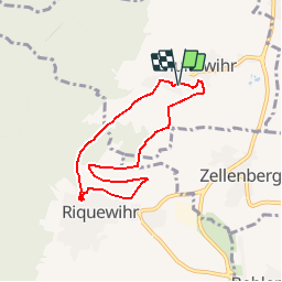
Hunawihr - Riquewihr

JMCMoreau
Gebruiker

Lengte
6,3 km

Max. hoogte
382 m

Positief hoogteverschil
207 m
Km-Effort
9 km

Min. hoogte
251 m

Negatief hoogteverschil
200 m
Boucle
Ja
Datum van aanmaak :
2019-08-27 13:24:13.727
Laatste wijziging :
2019-08-27 14:23:54.906
2h15
Moeilijkheid : Gemakkelijk

Gratisgps-wandelapplicatie
 SityTrail
IGN / Geografische instituten
SityTrail Plus
De wereld gaat voor u open
Over ons
Tocht Stappen van 6,3 km beschikbaar op Grand Est, Haut-Rhin, Hunawihr. Deze tocht wordt voorgesteld door JMCMoreau.
Beschrijving
Parcours PR avec Pique-nique PR & GR Rue Sainte HUNE près du lavoir.
Plaatsbepaling
Land:
France
Regio :
Grand Est
Departement/Provincie :
Haut-Rhin
Gemeente :
Hunawihr
Locatie:
Unknown
Vertrek:(Dec)
Vertrek:(UTM)
374396 ; 5337606 (32U) N.
Opmerkingen
Très Sympa Plein de belles vues