


maasmechelen 2

lerson
Gebruiker
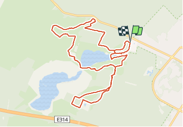

Lengte
11,3 km

Max. hoogte
101 m

Positief hoogteverschil
204 m
Km-Effort
14,1 km

Min. hoogte
57 m

Negatief hoogteverschil
205 m
Boucle
Ja
Datum van aanmaak :
2019-09-01 12:08:11.075
Laatste wijziging :
2019-09-01 18:52:14.452
3h29
Moeilijkheid : Heel gemakkelijk

Gratisgps-wandelapplicatie
 SityTrail
IGN / Geografische instituten
SityTrail Plus
De wereld gaat voor u open
Over ons
Tocht Stappen van 11,3 km beschikbaar op Vlaanderen, Limburg, Maasmechelen. Deze tocht wordt voorgesteld door lerson.
Plaatsbepaling
Land:
Belgium
Regio :
Vlaanderen
Departement/Provincie :
Limburg
Gemeente :
Maasmechelen
Locatie:
Mechelen-aan-de-Maas
Vertrek:(Dec)
Vertrek:(UTM)
686662 ; 5650696 (31U) N.
Opmerkingen