


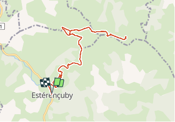
esterençuby fait

LouisROGER
Gebruiker GUIDE

Lengte
12,8 km

Max. hoogte
725 m

Positief hoogteverschil
575 m
Km-Effort
20 km

Min. hoogte
231 m

Negatief hoogteverschil
577 m
Boucle
Ja
Datum van aanmaak :
2019-09-02 06:57:55.12
Laatste wijziging :
2019-09-02 12:41:42.936
5h41
Moeilijkheid : Heel gemakkelijk

Gratisgps-wandelapplicatie
 SityTrail
IGN / Geografische instituten
SityTrail Plus
De wereld gaat voor u open
Over ons
Tocht Stappen van 12,8 km beschikbaar op Nieuw-Aquitanië, Pyrénées-Atlantiques, Estérençuby. Deze tocht wordt voorgesteld door LouisROGER.
Foto's


Plaatsbepaling
Land:
France
Regio :
Nieuw-Aquitanië
Departement/Provincie :
Pyrénées-Atlantiques
Gemeente :
Estérençuby
Locatie:
Unknown
Vertrek:(Dec)
Vertrek:(UTM)
646829 ; 4773984 (30T) N.
Opmerkingen