![](/images/other/stat-length.png)
![Tocht Stappen Sanilhac-Sagriès - Sanilhac Sagriès les Gorges et la Grotte - Photo](https://media.geolcdn.com/t/1900/400/ext.pjpeg?maxdim=2&url=https%3A%2F%2Fmedia.geolcdn.com%2Ff%2F8e3a9615-9625-4968-bd3b-1818306b2419.jpg)
Sanilhac Sagriès les Gorges et la Grotte
olivierchauchoy
Gebruiker
![Lengte](/images/other/stat-length.png)
![Max. hoogte](https://static1.geolcdn.com/siteimages/upload/files/1508320355ic_sort_altitude_max_24dp.png)
![Positief hoogteverschil](https://static1.geolcdn.com/siteimages/upload/files/1508320355ic_sort_den_pos_24dp.png)
![Km-Effort](/images/other/stat-length.png)
![Min. hoogte](https://static1.geolcdn.com/siteimages/upload/files/1508320355ic_sort_altitude_min_24dp.png)
![Negatief hoogteverschil](https://static1.geolcdn.com/siteimages/upload/files/1508320355ic_sort_den_neg_24dp.png)
![Boucle](https://static1.geolcdn.com/siteimages/upload/files/16400158638029165_repeat_loop_refresh_sync_direction_icon.png)
![Stappen](https://static1.geolcdn.com/sitytour/trail-icons/101.png)
2h25
Moeilijkheid : Medium
![Scan deze QR-code om de tocht te openen in de SityTrail-applicatie](https://capi.geolives.com/qq0zvz2zws4bq2lad0pu/sitytour/trails/2194002/qr.png?size=200)
Gratisgps-wandelapplicatie
Over ons
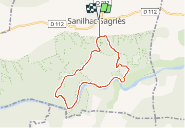
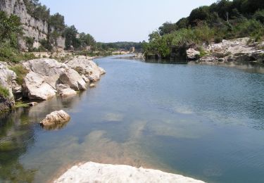
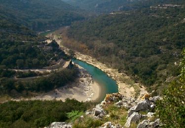
Tocht Stappen van 8,2 km beschikbaar op Occitanië, Gard, Sanilhac-Sagriès. Deze tocht wordt voorgesteld door olivierchauchoy.
Beschrijving
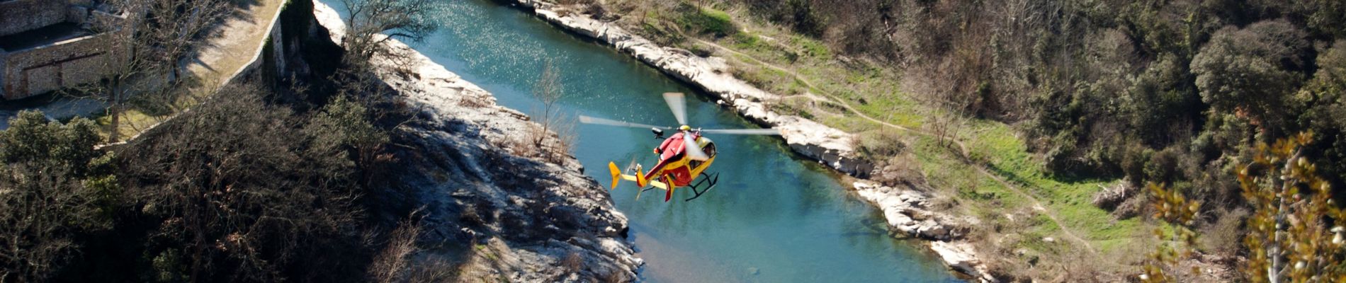
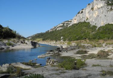
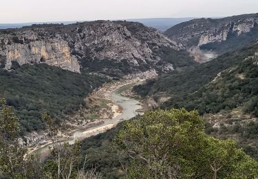
Très belle randonnée qui démarre de Sanilhac qui descend dans les Gorges, ensuite suivre le Gardon en trouvant un chemin ça et là passage sur les résurgences assez acrobatique, ensuite un chemin facile amène jusqu'à la grotte prévoir une lampe de poche (si la grotte est fermée prévoir une variante pour la remontée). A l'issue de la grotte le parcours est grimpant donc avoir de bonne jambes et des bras libres ! Arrivé sur le haut ça roule facile.
Plaatsbepaling
Opmerkingen
Wandeltochten in de omgeving
![Tocht Lopen Saint-Maximin - St-Maximin et la vallée d'Eure - Photo](https://media.geolcdn.com/t/375/260/ext.jpg?maxdim=2&url=https%3A%2F%2Fservices.sitytrail.com%2FGeolivesWS%2FDownloadMedia.ashx%3FTrailID%3D173131%26Media%3D14685_6.jpg)
![Lopen Lopen](https://static1.geolcdn.com/sitytour/trail-icons/103.png)
Lopen
![](/images/other/stat-length.png)
![](https://static1.geolcdn.com/siteimages/upload/files/16400158638029165_repeat_loop_refresh_sync_direction_icon.png)
![Tocht Stappen Collias - La Baume par Collias - Photo](https://media.geolcdn.com/t/375/260/ext.jpg?maxdim=2&url=https%3A%2F%2Fservices.sitytrail.com%2FGeolivesWS%2FDownloadMedia.ashx%3FTrailID%3D104695%26Media%3D8102_6.jpg)
![Stappen Stappen](https://static1.geolcdn.com/sitytour/trail-icons/101.png)
Stappen
![](/images/other/stat-length.png)
![](https://static1.geolcdn.com/siteimages/upload/files/16400158638029165_repeat_loop_refresh_sync_direction_icon.png)
![Tocht Stappen Collias - PF-Collias - Les Gorges du Gardon - Photo](https://media.geolcdn.com/t/375/260/ext.jpg?maxdim=2&url=https%3A%2F%2Fmedia.geolcdn.com%2Ff%2F811aaf22-76d4-41e7-bb26-03094e478fb2.JPG)
![Stappen Stappen](https://static1.geolcdn.com/sitytour/trail-icons/101.png)
Stappen
![](/images/other/stat-length.png)
![](https://static1.geolcdn.com/siteimages/upload/files/16400158638029165_repeat_loop_refresh_sync_direction_icon.png)
![Tocht Stappen Poulx - Balcon sur Gorges du Gardon - Photo](https://media.geolcdn.com/t/375/260/ext.jpg?maxdim=2&url=https%3A%2F%2Fmedia.geolcdn.com%2Ff%2Fb4f466dc-2d62-4b2c-95b4-3708a6ba2370.jpg)
![Stappen Stappen](https://static1.geolcdn.com/sitytour/trail-icons/101.png)
Stappen
![](/images/other/stat-length.png)
![](https://static1.geolcdn.com/siteimages/upload/files/16400158638029165_repeat_loop_refresh_sync_direction_icon.png)
![Tocht Te voet Collias - L'Ermitage de Collias - Photo](https://media.geolcdn.com/t/375/260/ext.jpg?maxdim=2&url=https%3A%2F%2Fmedia.geolcdn.com%2Ff%2Fc473495e-e6e8-4c81-b296-56e817ace246.jpeg)
![Te voet Te voet](https://static1.geolcdn.com/sitytour/trail-icons/100.png)
Te voet
![](/images/other/stat-length.png)
![](https://static1.geolcdn.com/siteimages/upload/files/16400158638029165_repeat_loop_refresh_sync_direction_icon.png)
![Tocht Mountainbike Uzès - GARD VTT 2017 J3 - Photo](https://media.geolcdn.com/t/375/260/ext.jpg?maxdim=2&url=https%3A%2F%2Fstatic1.geolcdn.com%2Fsiteimages%2Fupload%2Ffiles%2F1524743154velo.jpg)
![Mountainbike Mountainbike](https://static1.geolcdn.com/sitytour/trail-icons/202.png)
Mountainbike
![](/images/other/stat-length.png)
![](https://static1.geolcdn.com/siteimages/upload/files/16400158638029165_repeat_loop_refresh_sync_direction_icon.png)
![Tocht Stappen Sanilhac-Sagriès - la baume - Photo](https://media.geolcdn.com/t/375/260/ext.jpg?maxdim=2&url=https%3A%2F%2Fservices.sitytrail.com%2FGeolivesWS%2FDownloadMedia.ashx%3FTrailID%3D393706%26Media%3Dfix__20150308134945.jpg)
![Stappen Stappen](https://static1.geolcdn.com/sitytour/trail-icons/101.png)
Stappen
![](/images/other/stat-length.png)
![](https://static1.geolcdn.com/siteimages/upload/files/16400158638029165_repeat_loop_refresh_sync_direction_icon.png)
![Tocht Stappen Collias - COLLIAS - ROCHERS TROUES - ERMITAGE LAVAL-COLIAS - 13.6Km - 04h00 - Dénivelé 250 m - Photo](https://media.geolcdn.com/t/375/260/ext.jpg?maxdim=2&url=https%3A%2F%2Fstatic1.geolcdn.com%2Fsiteimages%2Fupload%2Ffiles%2F1553511878bg_sport_marche.png)
![Stappen Stappen](https://static1.geolcdn.com/sitytour/trail-icons/101.png)
Stappen
![](/images/other/stat-length.png)
![](https://static1.geolcdn.com/siteimages/upload/files/16400158638029165_repeat_loop_refresh_sync_direction_icon.png)
![Tocht Stappen Sanilhac-Sagriès - Sanilhac Sagries 1 - Photo](https://media.geolcdn.com/t/375/260/ext.jpg?maxdim=2&url=https%3A%2F%2Fstatic1.geolcdn.com%2Fsiteimages%2Fupload%2Ffiles%2F1553511878bg_sport_marche.png)
![Stappen Stappen](https://static1.geolcdn.com/sitytour/trail-icons/101.png)
Stappen
![](/images/other/stat-length.png)
![](https://static1.geolcdn.com/siteimages/upload/files/16400158638029165_repeat_loop_refresh_sync_direction_icon.png)