


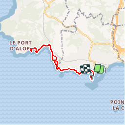
Bandol calanque d'Alon

bernir
Gebruiker

Lengte
14 km

Max. hoogte
84 m

Positief hoogteverschil
258 m
Km-Effort
17,4 km

Min. hoogte
-4 m

Negatief hoogteverschil
256 m
Boucle
Ja
Datum van aanmaak :
2019-09-12 07:07:59.579
Laatste wijziging :
2019-09-17 08:00:42.832
8h09
Moeilijkheid : Gemakkelijk

Gratisgps-wandelapplicatie
 SityTrail
IGN / Geografische instituten
SityTrail Plus
De wereld gaat voor u open
Over ons
Tocht Stappen van 14 km beschikbaar op Provence-Alpes-Côte d'Azur, Var, Bandol. Deze tocht wordt voorgesteld door bernir.
Plaatsbepaling
Land:
France
Regio :
Provence-Alpes-Côte d'Azur
Departement/Provincie :
Var
Gemeente :
Bandol
Locatie:
Unknown
Vertrek:(Dec)
Vertrek:(UTM)
723666 ; 4779039 (31T) N.
Opmerkingen