


grand et petit peric

signorato
Gebruiker

Lengte
22 km

Max. hoogte
2785 m

Positief hoogteverschil
1002 m
Km-Effort
35 km

Min. hoogte
2011 m

Negatief hoogteverschil
995 m
Boucle
Ja
Datum van aanmaak :
2019-09-12 07:19:47.878
Laatste wijziging :
2019-09-14 15:16:55.052
8h10
Moeilijkheid : Heel gemakkelijk

Gratisgps-wandelapplicatie
 SityTrail
IGN / Geografische instituten
SityTrail Plus
De wereld gaat voor u open
Over ons
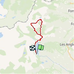
Tocht Stappen van 22 km beschikbaar op Occitanië, Pyrénées-Orientales, Angoustrine-Villeneuve-des-Escaldes. Deze tocht wordt voorgesteld door signorato.
Beschrijving
depart lac des Bouillouses
grand peric par sa corniche puis petit peric
puis. retour
Plaatsbepaling
Land:
France
Regio :
Occitanië
Departement/Provincie :
Pyrénées-Orientales
Gemeente :
Angoustrine-Villeneuve-des-Escaldes
Locatie:
Unknown
Vertrek:(Dec)
Vertrek:(UTM)
417730 ; 4712594 (31T) N.
Opmerkingen