


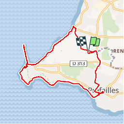
Pointe St Gildas 16 09 2019

FOUCAULT
Gebruiker

Lengte
9,9 km

Max. hoogte
26 m

Positief hoogteverschil
62 m
Km-Effort
10,8 km

Min. hoogte
0 m

Negatief hoogteverschil
62 m
Boucle
Ja
Datum van aanmaak :
2019-09-16 12:54:24.0
Laatste wijziging :
2019-09-16 16:56:18.231
4h01
Moeilijkheid : Onbekend

Gratisgps-wandelapplicatie
 SityTrail
IGN / Geografische instituten
SityTrail Plus
De wereld gaat voor u open
Over ons
Tocht Stappen van 9,9 km beschikbaar op Pays de la Loire, Loire-Atlantique, Préfailles. Deze tocht wordt voorgesteld door FOUCAULT.
Plaatsbepaling
Land:
France
Regio :
Pays de la Loire
Departement/Provincie :
Loire-Atlantique
Gemeente :
Préfailles
Locatie:
Unknown
Vertrek:(Dec)
Vertrek:(UTM)
558875 ; 5220886 (30T) N.
Opmerkingen