


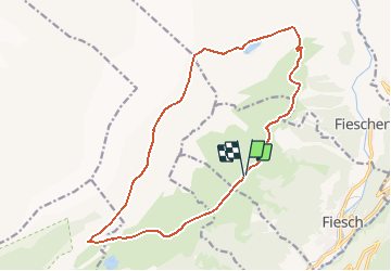
Glacier d''Aletsch depuis Fiesch

duamerg
Gebruiker


5h00
Moeilijkheid : Medium

Gratisgps-wandelapplicatie
 SityTrail
IGN / Geografische instituten
SityTrail Plus
De wereld gaat voor u open
Over ons
Tocht Stappen van 17,5 km beschikbaar op Valais/Wallis, Goms, Fiesch. Deze tocht wordt voorgesteld door duamerg.
Beschrijving
Prendre la télécabine à Fiesch et monter à Fiescheralp. Suivre les indications Marjelensee que l'on atteint après plus de 2 heures de marche. Comme apéritif admirez le Fieschergletscher. L'attente est récompensée par une vue grandiose de tout le glacier. La marche le long du glacier jusqu'à Biel / Moosfluh est magnifique (2h). Retour à Fiescheralp avec vue sur le Cervin et plusieurs 4000m dans le lointain.
Plaatsbepaling
Opmerkingen