Tocht Stappen Villars - Puyguilhem - Grotte de Villars - Photo

Puyguilhem - Grotte de Villars

 Zygomat
Zygomat

Gebruiker

© OpenStreetMap contributors
Lengte
Lengte
13,6 km
Max. hoogte
Max. hoogte
211 m
Positief hoogteverschil
259 m
Km-Effort
Km-Effort  
17,1 km
Min. hoogte
Min. hoogte
136 m
Negatief hoogteverschil
261 m
Boucle
Boucle
Ja
Datum van aanmaak :
2019-09-27 13:20:46.624
Laatste wijziging :
2022-08-25 14:37:57.522

(1 Bericht)

Stappen
Stappen
3h44
Moeilijkheid : Moeilijk

Scan deze QR-code om de tocht te openen in de SityTrail-applicatie

Gratisgps-wandelapplicatie

Logo SityTrail SityTrail

IGN / Geografische instituten

SityTrail uit de App Store downloaden SityTrail uit Google Play downloaden

Logo SityTrail SityTrail World

De wereld gaat voor u open

SityTrail uit de App Store downloaden SityTrail uit Google Play downloaden SityTrail op Huawei AppGallery downloaden

Over ons

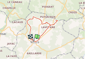
Tocht Stappen van 13,6 km beschikbaar op Nieuw-Aquitanië, Dordogne, Villars. Deze tocht wordt voorgesteld door Zygomat.

Beschrijving

Départ de Villars pour une visite du Chateau de Puyguilhem, ensuite cheminement vers le nord pour retrouver Laschenaud et aller visiter les Grottes de Villars. Retour à Villars. Le parcour emprunte la boucle PDIPR n°4 du guide du canton de Champagnac de Belair sauf à la sortie de Laschenaud où l'on se dirige directement vers Le Cluzeau

Hoogteprofiel

Plaatsbepaling

Land:
France
Regio :
Nieuw-Aquitanië
Departement/Provincie :
Dordogne
Gemeente :
Villars
Locatie:
Unknown
Vertrek:(UTM)
324213 ; 5032099 (31T) N.

Opmerkingen

Gelieve in te loggen om een commentaar of een beoordeling achter te laten


Wandeltochten in de omgeving

Tocht Stappen Villars - Villars Quinsac - Photo
Stappen
YV24

Stappen

Gemakkelijk
(1)
Villars, Nieuw-Aquitanië, Dordogne, France
13 km | 16,3 km-effort
3h 30min
Ja
Tocht Elektrische fiets Villars - Villars -Nontron 10/09/22 - Photo
Elektrische fiets
zoe.vienne

Elektrische fiets

Gemakkelijk
Villars, Nieuw-Aquitanië, Dordogne, France
34 km | 41 km-effort
2h 40min
Neen
Tocht Stappen Villars - Villars abbaye de Boschaud - Photo
Stappen
rougilabuse

Stappen

Medium
Villars, Nieuw-Aquitanië, Dordogne, France
12,4 km | 15,8 km-effort
3h 58min
Ja
Tocht Stappen Champagnac-de-Belair - Boucle de Champagnac de bel air - Photo
Stappen
Patricew

Stappen

Moeilijk
Champagnac-de-Belair, Nieuw-Aquitanië, Dordogne, France
12,7 km | 15,7 km-effort
3h 33min
Ja
Tocht Mountainbike Villars - Mareuil Pauliac Brantôme Pressillac - Photo
Mountainbike
charrier

Mountainbike

Medium
Villars, Nieuw-Aquitanië, Dordogne, France
109 km | 136 km-effort
8h 23min
Ja
Tocht Stappen Saint-Pierre-de-Côle - St Pierre de Côle Bruzac courte 12km - Photo
Stappen
YV24

Stappen

Gemakkelijk
Saint-Pierre-de-Côle, Nieuw-Aquitanië, Dordogne, France
11,5 km | 14,5 km-effort
3h 10min
Ja
Tocht Stappen Condat-sur-Trincou - Condat-sur-Trincou Dronne Trincou 13km - Photo
Stappen
YV24

Stappen

Gemakkelijk
Condat-sur-Trincou, Nieuw-Aquitanië, Dordogne, France
12,6 km | 15,8 km-effort
3h 26min
Ja
Tocht Stappen Champagnac-de-Belair - Champagnac Belair Drone Trincou - Photo
Stappen
YV24

Stappen

Gemakkelijk
Champagnac-de-Belair, Nieuw-Aquitanië, Dordogne, France
13,4 km | 16,7 km-effort
3h 36min
Ja
Tocht Stappen Villars - Villars les Puys - Photo
Stappen
YV24

Stappen

Gemakkelijk
Villars, Nieuw-Aquitanië, Dordogne, France
9,1 km | 11,4 km-effort
2h 28min
Ja


Sluiten
Mijn abonnementen