


32km nord beynost 3

Valery01
Gebruiker

Lengte
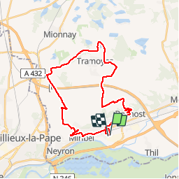
32 km

Max. hoogte
321 m

Positief hoogteverschil
320 m
Km-Effort
36 km

Min. hoogte
176 m

Negatief hoogteverschil
321 m
Boucle
Ja
Datum van aanmaak :
2014-12-10 00:00:00.0
Laatste wijziging :
2014-12-10 00:00:00.0
1h21
Moeilijkheid : Onbekend

Gratisgps-wandelapplicatie
 SityTrail
IGN / Geografische instituten
SityTrail Plus
De wereld gaat voor u open
Over ons
Tocht Fiets van 32 km beschikbaar op Auvergne-Rhône-Alpes, Ain, Saint-Maurice-de-Beynost. Deze tocht wordt voorgesteld door Valery01.
Plaatsbepaling
Land:
France
Regio :
Auvergne-Rhône-Alpes
Departement/Provincie :
Ain
Gemeente :
Saint-Maurice-de-Beynost
Locatie:
Unknown
Vertrek:(Dec)
Vertrek:(UTM)
653841 ; 5076548 (31T) N.
Opmerkingen