


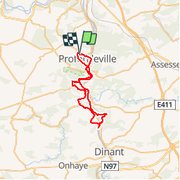
O2 Biker Profondeville

AlexTremProd
Gebruiker

Lengte
38 km

Max. hoogte
217 m

Positief hoogteverschil
844 m
Km-Effort
49 km

Min. hoogte
69 m

Negatief hoogteverschil
838 m
Boucle
Ja
Datum van aanmaak :
2014-12-10 00:00:00.0
Laatste wijziging :
2014-12-10 00:00:00.0
3h00
Moeilijkheid : Moeilijk

Gratisgps-wandelapplicatie
 SityTrail
IGN / Geografische instituten
SityTrail Plus
De wereld gaat voor u open
Over ons
Tocht Mountainbike van 38 km beschikbaar op Wallonië, Namen, Profondeville. Deze tocht wordt voorgesteld door AlexTremProd.
Beschrijving
Très beau parcours avec pas mal de montée. Encore un très beau O2 à faire
Plaatsbepaling
Land:
Belgium
Regio :
Wallonië
Departement/Provincie :
Namen
Gemeente :
Profondeville
Locatie:
Profondeville
Vertrek:(Dec)
Vertrek:(UTM)
631840 ; 5582821 (31U) N.
Opmerkingen