


Derscheid / Chateau de la hulpe

a_pascale
Gebruiker
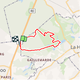

Lengte
9,7 km

Max. hoogte
146 m

Positief hoogteverschil
189 m
Km-Effort
12,2 km

Min. hoogte
61 m

Negatief hoogteverschil
187 m
Boucle
Ja
Datum van aanmaak :
2019-10-10 14:04:47.365
Laatste wijziging :
2019-10-10 14:05:44.524
2h00
Moeilijkheid : Heel gemakkelijk

Gratisgps-wandelapplicatie
 SityTrail
IGN / Geografische instituten
SityTrail Plus
De wereld gaat voor u open
Over ons
Tocht Te voet van 9,7 km beschikbaar op Wallonië, Waals-Brabant, Waterloo. Deze tocht wordt voorgesteld door a_pascale.
Plaatsbepaling
Land:
Belgium
Regio :
Wallonië
Departement/Provincie :
Waals-Brabant
Gemeente :
Waterloo
Locatie:
Waterloo
Vertrek:(Dec)
Vertrek:(UTM)
600404 ; 5621027 (31U) N.
Opmerkingen