


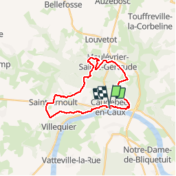
Caudebec en caux

pmauvieux
Gebruiker

Lengte
23 km

Max. hoogte
148 m

Positief hoogteverschil
464 m
Km-Effort
29 km

Min. hoogte
6 m

Negatief hoogteverschil
471 m
Boucle
Ja
Datum van aanmaak :
2019-10-12 07:44:36.664
Laatste wijziging :
2019-10-12 15:39:34.757
7h37
Moeilijkheid : Medium

Gratisgps-wandelapplicatie
 SityTrail
IGN / Geografische instituten
SityTrail Plus
De wereld gaat voor u open
Over ons
Tocht Stappen van 23 km beschikbaar op Normandië, Seine-Maritime, Rives-en-Seine. Deze tocht wordt voorgesteld door pmauvieux.
Plaatsbepaling
Land:
France
Regio :
Normandië
Departement/Provincie :
Seine-Maritime
Gemeente :
Rives-en-Seine
Locatie:
Unknown
Vertrek:(Dec)
Vertrek:(UTM)
335206 ; 5488334 (31U) N.
Opmerkingen