


Vignols

newman
Gebruiker
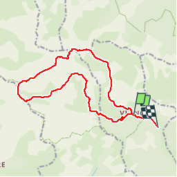

Lengte
17,4 km

Max. hoogte
2791 m

Positief hoogteverschil
1379 m
Km-Effort
36 km

Min. hoogte
1546 m

Negatief hoogteverschil
1450 m
Boucle
Neen
Datum van aanmaak :
2019-10-12 07:31:12.451
Laatste wijziging :
2019-10-12 15:44:26.873
6h50
Moeilijkheid : Heel gemakkelijk

Gratisgps-wandelapplicatie
 SityTrail
IGN / Geografische instituten
SityTrail Plus
De wereld gaat voor u open
Over ons
Tocht Stappen van 17,4 km beschikbaar op Provence-Alpes-Côte d'Azur, Alpes-Maritimes, Roubion. Deze tocht wordt voorgesteld door newman.
Plaatsbepaling
Land:
France
Regio :
Provence-Alpes-Côte d'Azur
Departement/Provincie :
Alpes-Maritimes
Gemeente :
Roubion
Locatie:
Unknown
Vertrek:(Dec)
Vertrek:(UTM)
340882 ; 4888981 (32T) N.
Opmerkingen