


LINTHAL2

patrickbeyrath
Gebruiker
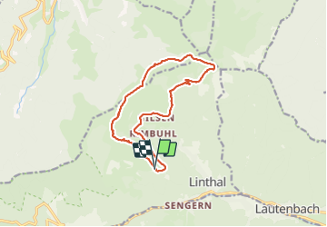

Lengte
13,2 km

Max. hoogte
1223 m

Positief hoogteverschil
439 m
Km-Effort
19 km

Min. hoogte
826 m

Negatief hoogteverschil
444 m
Boucle
Ja
Datum van aanmaak :
2018-10-13 05:53:18.116
Laatste wijziging :
2018-10-13 05:53:18.169
6h20
Moeilijkheid : Gemakkelijk

Gratisgps-wandelapplicatie
 SityTrail
IGN / Geografische instituten
SityTrail Plus
De wereld gaat voor u open
Over ons
Tocht Stappen van 13,2 km beschikbaar op Grand Est, Haut-Rhin, Linthal. Deze tocht wordt voorgesteld door patrickbeyrath.
Plaatsbepaling
Land:
France
Regio :
Grand Est
Departement/Provincie :
Haut-Rhin
Gemeente :
Linthal
Locatie:
Unknown
Vertrek:(Dec)
Vertrek:(UTM)
358797 ; 5312622 (32T) N.
Opmerkingen