


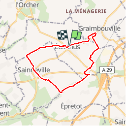
Etainhus Circuit de la Garenne ne points bleus

DDLEDANDY
Gebruiker

Lengte
11,9 km

Max. hoogte
127 m

Positief hoogteverschil
123 m
Km-Effort
13,5 km

Min. hoogte
86 m

Negatief hoogteverschil
124 m
Boucle
Ja
Datum van aanmaak :
2019-10-15 07:11:21.575
Laatste wijziging :
2019-10-15 09:55:39.003
2h36
Moeilijkheid : Medium

Gratisgps-wandelapplicatie
 SityTrail
IGN / Geografische instituten
SityTrail Plus
De wereld gaat voor u open
Over ons
Tocht Stappen van 11,9 km beschikbaar op Normandië, Seine-Maritime, Étainhus. Deze tocht wordt voorgesteld door DDLEDANDY.
Plaatsbepaling
Land:
France
Regio :
Normandië
Departement/Provincie :
Seine-Maritime
Gemeente :
Étainhus
Locatie:
Unknown
Vertrek:(Dec)
Vertrek:(UTM)
305625 ; 5494000 (31U) N.
Opmerkingen