


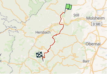
Circuit VC Oberhaslach - Fouday

Tourisme Equestre Alsace
Promouvoir le Tourisme Equestre en Alsace GUIDE+

Lengte
29 km

Max. hoogte
1008 m

Positief hoogteverschil
1326 m
Km-Effort
45 km

Min. hoogte
231 m

Negatief hoogteverschil
629 m
Boucle
Neen
Datum van aanmaak :
2015-07-24 00:00:00.0
Laatste wijziging :
2024-02-12 09:37:09.133
7h12
Moeilijkheid : Zeer moeilijk

Gratisgps-wandelapplicatie
 SityTrail
IGN / Geografische instituten
SityTrail Plus
De wereld gaat voor u open
Over ons
Tocht Paardrijden van 29 km beschikbaar op Grand Est, Bas-Rhin, Niederhaslach. Deze tocht wordt voorgesteld door Tourisme Equestre Alsace.
Beschrijving
Circuit VC Oberhaslach - Fouday
Foto's

POI's


Plaatsbepaling
Land:
France
Regio :
Grand Est
Departement/Provincie :
Bas-Rhin
Gemeente :
Niederhaslach
Locatie:
Unknown
Vertrek:(Dec)
Vertrek:(UTM)
378292 ; 5379435 (32U) N.
Opmerkingen