


weer langs de abdij

koen.knaepen
Gebruiker
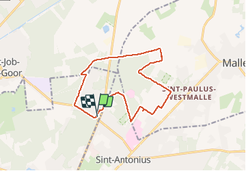

Lengte
13,4 km

Max. hoogte
38 m

Positief hoogteverschil
96 m
Km-Effort
14,7 km

Min. hoogte
17 m

Negatief hoogteverschil
95 m
Boucle
Ja
Datum van aanmaak :
2014-12-10 00:00:00.0
Laatste wijziging :
2014-12-10 00:00:00.0
1h39
Moeilijkheid : Onbekend

Gratisgps-wandelapplicatie
 SityTrail
IGN / Geografische instituten
SityTrail Plus
De wereld gaat voor u open
Over ons
Tocht Lopen van 13,4 km beschikbaar op Vlaanderen, Antwerpen, Schilde. Deze tocht wordt voorgesteld door koen.knaepen.
Plaatsbepaling
Land:
Belgium
Regio :
Vlaanderen
Departement/Provincie :
Antwerpen
Gemeente :
Schilde
Locatie:
Schilde
Vertrek:(Dec)
Vertrek:(UTM)
613252 ; 5682231 (31U) N.
Opmerkingen