


Vosges - La Bresse - Lac de Lispach

nicolasbarbarin
Gebruiker
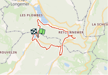

Lengte
16,4 km

Max. hoogte
1011 m

Positief hoogteverschil
569 m
Km-Effort
24 km

Min. hoogte
735 m

Negatief hoogteverschil
568 m
Boucle
Ja
Datum van aanmaak :
2019-10-28 09:57:20.0
Laatste wijziging :
2020-07-05 08:51:52.401
6h02
Moeilijkheid : Moeilijk

Gratisgps-wandelapplicatie
 SityTrail
IGN / Geografische instituten
SityTrail Plus
De wereld gaat voor u open
Over ons
Tocht Stappen van 16,4 km beschikbaar op Grand Est, Vogezen, La Bresse. Deze tocht wordt voorgesteld door nicolasbarbarin.
Plaatsbepaling
Land:
France
Regio :
Grand Est
Departement/Provincie :
Vogezen
Gemeente :
La Bresse
Locatie:
Unknown
Vertrek:(Dec)
Vertrek:(UTM)
347066 ; 5324236 (32U) N.
Opmerkingen