


2019-10-29_09h54m26_luminy-cassis (1)

HG74250
Gebruiker

Lengte
16,5 km

Max. hoogte
428 m

Positief hoogteverschil
653 m
Km-Effort
26 km

Min. hoogte
5 m

Negatief hoogteverschil
784 m
Boucle
Neen
Datum van aanmaak :
2019-10-29 08:54:26.579
Laatste wijziging :
2020-01-04 17:04:43.224
--
Moeilijkheid : Gemakkelijk

Gratisgps-wandelapplicatie
 SityTrail
IGN / Geografische instituten
SityTrail Plus
De wereld gaat voor u open
Over ons
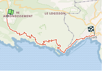
Tocht Te voet van 16,5 km beschikbaar op Provence-Alpes-Côte d'Azur, Bouches-du-Rhône, Marseille. Deze tocht wordt voorgesteld door HG74250.
Plaatsbepaling
Land:
France
Regio :
Provence-Alpes-Côte d'Azur
Departement/Provincie :
Bouches-du-Rhône
Gemeente :
Marseille
Locatie:
9e Arrondissement
Vertrek:(Dec)
Vertrek:(UTM)
697883 ; 4789283 (31T) N.
Opmerkingen