


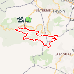
Pichauris mont du Marseillais 2 novembre 2019

rlebasque
Gebruiker

Lengte
17,2 km

Max. hoogte
628 m

Positief hoogteverschil
528 m
Km-Effort
24 km

Min. hoogte
296 m

Negatief hoogteverschil
529 m
Boucle
Ja
Datum van aanmaak :
2019-11-02 06:55:38.204
Laatste wijziging :
2019-11-03 06:43:38.686
5h59
Moeilijkheid : Heel gemakkelijk

Gratisgps-wandelapplicatie
 SityTrail
IGN / Geografische instituten
SityTrail Plus
De wereld gaat voor u open
Over ons
Tocht Stappen van 17,2 km beschikbaar op Provence-Alpes-Côte d'Azur, Bouches-du-Rhône, Allauch. Deze tocht wordt voorgesteld door rlebasque.
Plaatsbepaling
Land:
France
Regio :
Provence-Alpes-Côte d'Azur
Departement/Provincie :
Bouches-du-Rhône
Gemeente :
Allauch
Locatie:
Unknown
Vertrek:(Dec)
Vertrek:(UTM)
705543 ; 4805085 (31T) N.
Opmerkingen