


ORAISON Paoure. Le Relais Chapelle Pancrace . Les Buissonades o

RobinMicheline
Gebruiker GUIDE
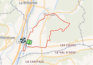

Lengte
16,7 km

Max. hoogte
608 m

Positief hoogteverschil
313 m
Km-Effort
21 km

Min. hoogte
325 m

Negatief hoogteverschil
312 m
Boucle
Ja
Datum van aanmaak :
2019-11-08 10:26:50.886
Laatste wijziging :
2020-01-22 19:43:07.727
5h09
Moeilijkheid : Medium

Gratisgps-wandelapplicatie
 SityTrail
IGN / Geografische instituten
SityTrail Plus
De wereld gaat voor u open
Over ons
Tocht Stappen van 16,7 km beschikbaar op Provence-Alpes-Côte d'Azur, Alpes-de-Haute-Provence, Oraison. Deze tocht wordt voorgesteld door RobinMicheline.
Beschrijving
Un peu long
Plaatsbepaling
Land:
France
Regio :
Provence-Alpes-Côte d'Azur
Departement/Provincie :
Alpes-de-Haute-Provence
Gemeente :
Oraison
Locatie:
Unknown
Vertrek:(Dec)
Vertrek:(UTM)
732017 ; 4863104 (31T) N.
Opmerkingen