


bouglainval 10

topophil
Gebruiker
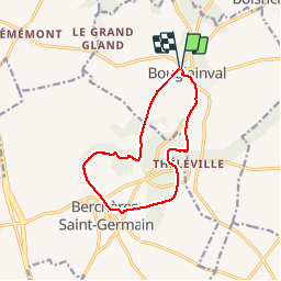

Lengte
10,8 km

Max. hoogte
178 m

Positief hoogteverschil
129 m
Km-Effort
12,5 km

Min. hoogte
129 m

Negatief hoogteverschil
129 m
Boucle
Ja
Datum van aanmaak :
2019-11-26 13:13:54.919
Laatste wijziging :
2019-11-26 15:44:43.859
2h17
Moeilijkheid : Heel gemakkelijk

Gratisgps-wandelapplicatie
 SityTrail
IGN / Geografische instituten
SityTrail Plus
De wereld gaat voor u open
Over ons
Tocht Stappen van 10,8 km beschikbaar op Centre-Val de Loire, Eure-et-Loir, Bouglainval. Deze tocht wordt voorgesteld door topophil.
Plaatsbepaling
Land:
France
Regio :
Centre-Val de Loire
Departement/Provincie :
Eure-et-Loir
Gemeente :
Bouglainval
Locatie:
Unknown
Vertrek:(Dec)
Vertrek:(UTM)
389722 ; 5380151 (31U) N.
Opmerkingen