


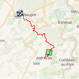
anthisne - Rotheux

maleclere
Gebruiker

Lengte
13,5 km

Max. hoogte
291 m

Positief hoogteverschil
424 m
Km-Effort
19,1 km

Min. hoogte
149 m

Negatief hoogteverschil
404 m
Boucle
Neen
Datum van aanmaak :
2019-12-02 10:20:12.439
Laatste wijziging :
2019-12-02 10:20:55.012
--
Moeilijkheid : Medium

Gratisgps-wandelapplicatie
 SityTrail
IGN / Geografische instituten
SityTrail Plus
De wereld gaat voor u open
Over ons
Tocht Te voet van 13,5 km beschikbaar op Wallonië, Luik, Anthisnes. Deze tocht wordt voorgesteld door maleclere.
Plaatsbepaling
Land:
Belgium
Regio :
Wallonië
Departement/Provincie :
Luik
Gemeente :
Anthisnes
Locatie:
Anthisnes
Vertrek:(Dec)
Vertrek:(UTM)
679054 ; 5595006 (31U) N.
Opmerkingen