


Cazilhac VM01

dufland
Gebruiker

Lengte
8 km

Max. hoogte
231 m

Positief hoogteverschil
126 m
Km-Effort
9,7 km

Min. hoogte
133 m

Negatief hoogteverschil
129 m
Boucle
Ja
Datum van aanmaak :
2019-12-03 13:10:05.293
Laatste wijziging :
2022-02-02 15:07:38.606
2h23
Moeilijkheid : Heel gemakkelijk

Gratisgps-wandelapplicatie
 SityTrail
IGN / Geografische instituten
SityTrail Plus
De wereld gaat voor u open
Over ons
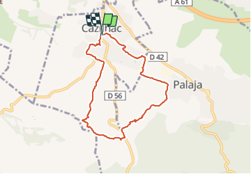
Tocht Stappen van 8 km beschikbaar op Occitanië, Aude, Cazilhac. Deze tocht wordt voorgesteld door dufland.
Beschrijving
Suivre les marques 2 trais jaune, 1 petit / 1 grand
Plaatsbepaling
Land:
France
Regio :
Occitanië
Departement/Provincie :
Aude
Gemeente :
Cazilhac
Locatie:
Unknown
Vertrek:(Dec)
Vertrek:(UTM)
448104 ; 4781385 (31T) N.
Opmerkingen