


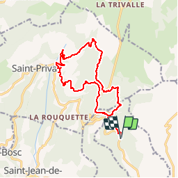
Arboras La Platriere - Les Salces- Pas de l'Azé

philcll
Gebruiker

Lengte
18 km

Max. hoogte
753 m

Positief hoogteverschil
808 m
Km-Effort
29 km

Min. hoogte
305 m

Negatief hoogteverschil
808 m
Boucle
Ja
Datum van aanmaak :
2019-12-05 08:28:58.503
Laatste wijziging :
2019-12-05 16:05:18.372
5h04
Moeilijkheid : Medium

Gratisgps-wandelapplicatie
 SityTrail
IGN / Geografische instituten
SityTrail Plus
De wereld gaat voor u open
Over ons
Tocht Stappen van 18 km beschikbaar op Occitanië, Hérault, Arboras. Deze tocht wordt voorgesteld door philcll.
Foto's

Plaatsbepaling
Land:
France
Regio :
Occitanië
Departement/Provincie :
Hérault
Gemeente :
Arboras
Locatie:
Unknown
Vertrek:(Dec)
Vertrek:(UTM)
537683 ; 4841782 (31T) N.
Opmerkingen
Très belle randonnée. Par contre, il faut changer le point de départ, par exemple sur le parking du Col du Vent, Les 2 premiers km aller qui sont les mêmes au retour, sont très caillouteux, si à l'aller en montée c'est praticable, par contre au retour avec la fatigue c'est infernal...