


Auriol ravin des infernets

bernir
Gebruiker
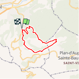

Lengte
12,1 km

Max. hoogte
739 m

Positief hoogteverschil
542 m
Km-Effort
19,4 km

Min. hoogte
244 m

Negatief hoogteverschil
542 m
Boucle
Ja
Datum van aanmaak :
2019-12-06 08:29:12.606
Laatste wijziging :
2019-12-06 20:32:56.258
5h46
Moeilijkheid : Moeilijk

Gratisgps-wandelapplicatie
 SityTrail
IGN / Geografische instituten
SityTrail Plus
De wereld gaat voor u open
Over ons
Tocht Stappen van 12,1 km beschikbaar op Provence-Alpes-Côte d'Azur, Bouches-du-Rhône, Auriol. Deze tocht wordt voorgesteld door bernir.
Plaatsbepaling
Land:
France
Regio :
Provence-Alpes-Côte d'Azur
Departement/Provincie :
Bouches-du-Rhône
Gemeente :
Auriol
Locatie:
Unknown
Vertrek:(Dec)
Vertrek:(UTM)
715553 ; 4803235 (31T) N.
Opmerkingen