


vaux MB 6 12 19

bstebe
Gebruiker
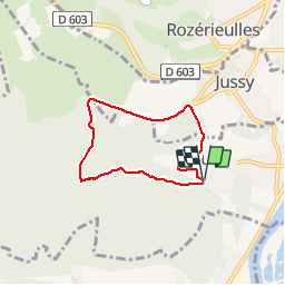

Lengte
5,3 km

Max. hoogte
335 m

Positief hoogteverschil
126 m
Km-Effort
7 km

Min. hoogte
210 m

Negatief hoogteverschil
134 m
Boucle
Ja
Datum van aanmaak :
2019-12-07 09:20:53.37
Laatste wijziging :
2019-12-07 11:17:46.023
1h56
Moeilijkheid : Heel gemakkelijk

Gratisgps-wandelapplicatie
 SityTrail
IGN / Geografische instituten
SityTrail Plus
De wereld gaat voor u open
Over ons
Tocht Stappen van 5,3 km beschikbaar op Grand Est, Moselle, Vaux. Deze tocht wordt voorgesteld door bstebe.
Plaatsbepaling
Land:
France
Regio :
Grand Est
Departement/Provincie :
Moselle
Gemeente :
Vaux
Locatie:
Unknown
Vertrek:(Dec)
Vertrek:(UTM)
286921 ; 5441761 (32U) N.
Opmerkingen