Tocht Stappen Eyguières - EYGUIERES - Photo
 FLORENSAC
FLORENSAC

Gebruiker

© OpenStreetMap contributors
Lengte
Lengte
17,3 km
Max. hoogte
Max. hoogte
231 m
Positief hoogteverschil
424 m
Km-Effort
Km-Effort  
23 km
Min. hoogte
Min. hoogte
104 m
Negatief hoogteverschil
423 m
Boucle
Boucle
Ja
Datum van aanmaak :
2019-12-08 08:48:53.892
Laatste wijziging :
2019-12-14 14:07:38.556

(0 Bericht)

Stappen
Stappen
6h09
Moeilijkheid : Medium

Scan deze QR-code om de tocht te openen in de SityTrail-applicatie

Gratisgps-wandelapplicatie

Logo SityTrail SityTrail

IGN / Geografische instituten

SityTrail uit de App Store downloaden SityTrail uit Google Play downloaden

Logo SityTrail SityTrail Plus

De wereld gaat voor u open

SityTrail uit de App Store downloaden SityTrail uit Google Play downloaden SityTrail op Huawei AppGallery downloaden

Over ons

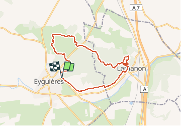
Tocht Stappen van 17,3 km beschikbaar op Provence-Alpes-Côte d'Azur, Bouches-du-Rhône, Eyguières. Deze tocht wordt voorgesteld door FLORENSAC.

Beschrijving

Jolie randonnée sans difficultées particulières hormis
visiter en passant les grottes de cales et son ancien village troglodyte

un endroit ou le chemin n'est
plus balisé bien suivre le tracé gps
SINON ON PEUT PASSER PLUS BAS
Visite en passant du chateau en ruine de la Reine Jeanne
et sa très jolie chapelle

Hoogteprofiel

Plaatsbepaling

Land:
France
Regio :
Provence-Alpes-Côte d'Azur
Departement/Provincie :
Bouches-du-Rhône
Gemeente :
Eyguières
Locatie:
Unknown
Vertrek:(UTM)
664320 ; 4840219 (31T) N.


Sluiten
Mijn abonnementen