


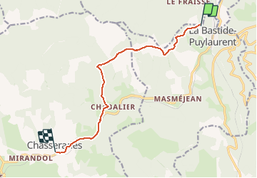
La bastide puy Laurent Chasserades

ARVIEU
Gebruiker

Lengte
10,2 km

Max. hoogte
1313 m

Positief hoogteverschil
267 m
Km-Effort
13,6 km

Min. hoogte
1122 m

Negatief hoogteverschil
239 m
Boucle
Neen
Datum van aanmaak :
2019-12-14 19:36:08.463
Laatste wijziging :
2019-12-14 19:37:42.949
3h30
Moeilijkheid : Medium

Gratisgps-wandelapplicatie
 SityTrail
IGN / Geografische instituten
SityTrail Plus
De wereld gaat voor u open
Over ons
Tocht Te voet van 10,2 km beschikbaar op Occitanië, Lozère, La Bastide-Puylaurent. Deze tocht wordt voorgesteld door ARVIEU.
Plaatsbepaling
Land:
France
Regio :
Occitanië
Departement/Provincie :
Lozère
Gemeente :
La Bastide-Puylaurent
Locatie:
Unknown
Vertrek:(Dec)
Vertrek:(UTM)
571220 ; 4938213 (31T) N.
Opmerkingen