


Marche l'après-midi

holtzv
Gebruiker GUIDE
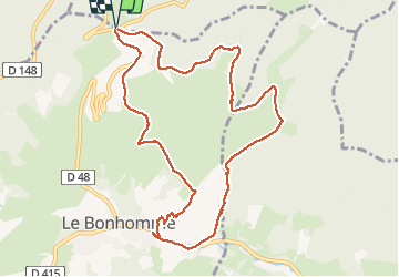

Lengte
10,7 km

Max. hoogte
987 m

Positief hoogteverschil
434 m
Km-Effort
16,5 km

Min. hoogte
661 m

Negatief hoogteverschil
437 m
Boucle
Ja
Datum van aanmaak :
2020-01-01 19:04:19.355
Laatste wijziging :
2020-01-02 18:17:08.774
3h24
Moeilijkheid : Moeilijk

Gratisgps-wandelapplicatie
 SityTrail
IGN / Geografische instituten
SityTrail Plus
De wereld gaat voor u open
Over ons
Tocht Stappen van 10,7 km beschikbaar op Grand Est, Haut-Rhin, Sainte-Marie-aux-Mines. Deze tocht wordt voorgesteld door holtzv.
Foto's


Plaatsbepaling
Land:
France
Regio :
Grand Est
Departement/Provincie :
Haut-Rhin
Gemeente :
Sainte-Marie-aux-Mines
Locatie:
Unknown
Vertrek:(Dec)
Vertrek:(UTM)
359839 ; 5339444 (32U) N.
Opmerkingen