Tocht Stappen Hyères - m8l - Photo
 ymobernard
ymobernard

Gebruiker

© OpenStreetMap contributors
Lengte
Lengte
11,5 km
Max. hoogte
Max. hoogte
86 m
Positief hoogteverschil
257 m
Km-Effort
Km-Effort  
14,9 km
Min. hoogte
Min. hoogte
-1 m
Negatief hoogteverschil
237 m
Boucle
Boucle
Neen
Datum van aanmaak :
2020-01-06 08:17:56.795
Laatste wijziging :
2020-01-07 05:27:17.895

(0 Bericht)

Stappen
Stappen
3h28
Moeilijkheid : Medium

Scan deze QR-code om de tocht te openen in de SityTrail-applicatie

Gratisgps-wandelapplicatie

Logo SityTrail SityTrail

IGN / Geografische instituten

SityTrail uit de App Store downloaden SityTrail uit Google Play downloaden

Logo SityTrail SityTrail Plus

De wereld gaat voor u open

SityTrail uit de App Store downloaden SityTrail uit Google Play downloaden SityTrail op Huawei AppGallery downloaden

Over ons

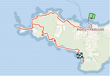
Tocht Stappen van 11,5 km beschikbaar op Provence-Alpes-Côte d'Azur, Var, Hyères. Deze tocht wordt voorgesteld door ymobernard.

Beschrijving

On ne omLe texte que vous copiez s'affichera automatiquement iciLe texte que vous copiez s'affichera automatiquement iciLe texte que vous copiez s'affichera automatiquement iciFaites glisser des clips pour les supprimerLe texte que vous copiez s'affichera automatiquement iciÉpinglez les morceaux de texte copiés pour qu'ils n'expirent pas après 1 heure

Hoogteprofiel

Plaatsbepaling

Land:
France
Regio :
Provence-Alpes-Côte d'Azur
Departement/Provincie :
Var
Gemeente :
Hyères
Locatie:
Unknown
Vertrek:(UTM)
271850 ; 4764941 (32T) N.


Sluiten
Mijn abonnementen