


st pons la calm

mthomas30
Gebruiker
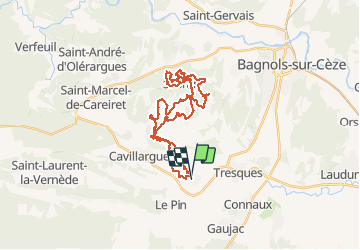

Lengte
34 km

Max. hoogte
289 m

Positief hoogteverschil
732 m
Km-Effort
43 km

Min. hoogte
109 m

Negatief hoogteverschil
729 m
Boucle
Ja
Datum van aanmaak :
2020-01-19 07:21:19.614
Laatste wijziging :
2020-01-19 11:06:22.524
3h43
Moeilijkheid : Medium

Gratisgps-wandelapplicatie
 SityTrail
IGN / Geografische instituten
SityTrail Plus
De wereld gaat voor u open
Over ons
Tocht Mountainbike van 34 km beschikbaar op Occitanië, Gard, Saint-Pons-la-Calm. Deze tocht wordt voorgesteld door mthomas30.
Plaatsbepaling
Land:
France
Regio :
Occitanië
Departement/Provincie :
Gard
Gemeente :
Saint-Pons-la-Calm
Locatie:
Unknown
Vertrek:(Dec)
Vertrek:(UTM)
624433 ; 4884681 (31T) N.
Opmerkingen