


panorama-perche

olivieraron
Gebruiker
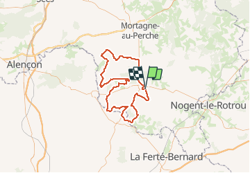

Lengte
97 km

Max. hoogte
245 m

Positief hoogteverschil
1277 m
Km-Effort
114 km

Min. hoogte
75 m

Negatief hoogteverschil
1285 m
Boucle
Ja
Datum van aanmaak :
2020-01-25 12:16:00.0
Laatste wijziging :
2020-01-25 12:21:03.193

Gratisgps-wandelapplicatie
 SityTrail
IGN / Geografische instituten
SityTrail Plus
De wereld gaat voor u open
Over ons
Tocht van 97 km beschikbaar op Normandië, Orne, Belforêt-en-Perche. Deze tocht wordt voorgesteld door olivieraron.
Plaatsbepaling
Land:
France
Regio :
Normandië
Departement/Provincie :
Orne
Gemeente :
Belforêt-en-Perche
Locatie:
Sérigny
Vertrek:(Dec)
Vertrek:(UTM)
320132 ; 5359801 (31U) N.
Opmerkingen