Tocht Huifkarwandeling Rocles - Boucle Attelage 5 jours Margeride - Photo

Boucle Attelage 5 jours Margeride

 Lozère Cheval
Lozère Cheval

Gebruiker

© OpenStreetMap contributors
Lengte
Lengte
113 km
Max. hoogte
Max. hoogte
1414 m
Positief hoogteverschil
2146 m
Km-Effort
Km-Effort  
141 km
Min. hoogte
Min. hoogte
898 m
Negatief hoogteverschil
2147 m
Boucle
Boucle
Ja
Datum van aanmaak :
2020-01-30 17:05:40.652
Laatste wijziging :
2021-11-30 14:17:04.391

(0 Bericht)

Huifkarwandeling
Huifkarwandeling
--
Moeilijkheid : Heel gemakkelijk

Scan deze QR-code om de tocht te openen in de SityTrail-applicatie

Gratisgps-wandelapplicatie

Logo SityTrail SityTrail

IGN / Geografische instituten

SityTrail uit de App Store downloaden SityTrail uit Google Play downloaden

Logo SityTrail SityTrail World

De wereld gaat voor u open

SityTrail uit de App Store downloaden SityTrail uit Google Play downloaden SityTrail op Huawei AppGallery downloaden

Over ons

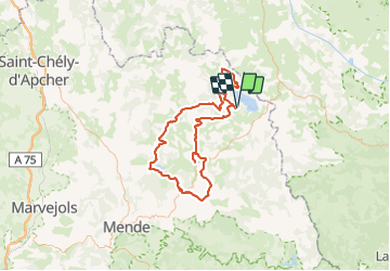
Tocht Huifkarwandeling van 113 km beschikbaar op Occitanië, Lozère, Rocles. Deze tocht wordt voorgesteld door Lozère Cheval.

Hoogteprofiel

POI's

POI Naussac-Fontanes - Grange de Pradelou - Photo
Lozère Cheval
NAUSSAC-FONTANES 
POI Rocles - Palhères - Photo
Lozère Cheval
ROCLES 
POI Arzenc-de-Randon - Le Giraldès  chez Valy - Photo
Lozère Cheval
ARZENC-DE-RANDON 
POI Arzenc-de-Randon - Hôtel de la Poste - Photo
Lozère Cheval
ARZENC-DE-RANDON 
POI Laubert - La Pontière - Photo
Lozère Cheval
LAUBERT 
POI Mont Lozère et Goulet - Hôtel les Sources Chasserades - Photo
Lozère Cheval
MONT LOZÈRE ET GOULET 

Plaatsbepaling

Land:
France
Regio :
Occitanië
Departement/Provincie :
Lozère
Gemeente :
Rocles
Locatie:
Unknown
Vertrek:(UTM)
561835 ; 4953503 (31T) N.

Wandeltochten in de omgeving

Tocht Stappen Naussac-Fontanes - naussac - Photo
Stappen
olivier78000

Stappen

Gemakkelijk
(1)
Naussac-Fontanes, Occitanië, Lozère, France
7,9 km | 10,2 km-effort
2h 6min
Ja
Tocht Mountainbike Langogne - Espace VTT FFC du Gévaudan - n°08 - Circuit  du Ras Chambon - Photo
Mountainbike
tracegps

Mountainbike

Moeilijk
(2)
Langogne, Occitanië, Lozère, France
17,2 km | 22 km-effort
2h 15min
Ja
Tocht Paardrijden Rocles - Jojo2  - Photo
Paardrijden
ophness

Paardrijden

Medium
(1)
Rocles, Occitanië, Lozère, France
17,3 km | 22 km-effort
2h 55min
Neen
Tocht Stappen Saint-Flour-de-Mercoire - le chélard - Photo
Stappen
jeanjean35

Stappen

Moeilijk
Saint-Flour-de-Mercoire, Occitanië, Lozère, France
11 km | 14,9 km-effort
3h 6min
Neen
Tocht Wegfiets Langogne - Langogne, le nouveau monde - Photo
Wegfiets
nadd73

Wegfiets

Medium
Langogne, Occitanië, Lozère, France
68 km | 85 km-effort
4h 31min
Ja
Tocht Lopen Rocles - Rocles - Photo
Lopen
nadd73

Lopen

Medium
Rocles, Occitanië, Lozère, France
14,8 km | 18,2 km-effort
1h 38min
Ja
Tocht Wegfiets Langogne - NAUSSAC - COL DE LA PIERRE PLANTEE - Photo
Wegfiets
jean-marie.parachini

Wegfiets

Gemakkelijk
Langogne, Occitanië, Lozère, France
76 km | 91 km-effort
6h 20min
Ja
Tocht Wegfiets Langogne - NAUSSAC - FORÊT DE MERCOIRE - Photo
Wegfiets
jean-marie.parachini

Wegfiets

Medium
Langogne, Occitanië, Lozère, France
68 km | 81 km-effort
5h 40min
Ja
Tocht Wegfiets Langogne - NAUSSAC - CHAPEAUROUX - Photo
Wegfiets
jean-marie.parachini

Wegfiets

Medium
Langogne, Occitanië, Lozère, France
74 km | 94 km-effort
6h 29min
Neen


Sluiten
Mijn abonnementen