


st Christophe

bouscaillou
Gebruiker
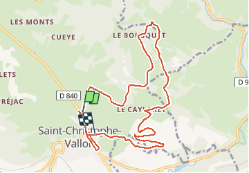

Lengte
11,9 km

Max. hoogte
539 m

Positief hoogteverschil
330 m
Km-Effort
16,2 km

Min. hoogte
312 m

Negatief hoogteverschil
310 m
Boucle
Neen
Datum van aanmaak :
2020-02-06 13:30:38.512
Laatste wijziging :
2020-02-06 16:41:35.879
3h09
Moeilijkheid : Heel gemakkelijk

Gratisgps-wandelapplicatie
 SityTrail
IGN / Geografische instituten
SityTrail Plus
De wereld gaat voor u open
Over ons
Tocht Stappen van 11,9 km beschikbaar op Occitanië, Aveyron, Saint-Christophe-Vallon. Deze tocht wordt voorgesteld door bouscaillou.
Plaatsbepaling
Land:
France
Regio :
Occitanië
Departement/Provincie :
Aveyron
Gemeente :
Saint-Christophe-Vallon
Locatie:
Unknown
Vertrek:(Dec)
Vertrek:(UTM)
453131 ; 4924741 (31T) N.
Opmerkingen