


The Ring of Brodgar and Stones of Stenness

cron
Gebruiker
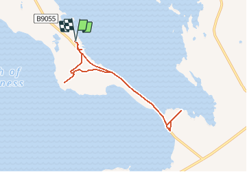

Lengte
5,5 km

Max. hoogte
13 m

Positief hoogteverschil
26 m
Km-Effort
5,9 km

Min. hoogte
0 m

Negatief hoogteverschil
26 m
Boucle
Ja
Datum van aanmaak :
2020-02-14 17:50:28.482
Laatste wijziging :
2020-02-14 17:57:44.159
1h20
Moeilijkheid : Heel gemakkelijk

Gratisgps-wandelapplicatie
 SityTrail
IGN / Geografische instituten
SityTrail Plus
De wereld gaat voor u open
Over ons
Tocht Te voet van 5,5 km beschikbaar op Schotland, Orkney Islands. Deze tocht wordt voorgesteld door cron.
Beschrijving
Peu de distance à parcourir mais beaucoup de choses à visiter !
Plaatsbepaling
Land:
United Kingdom
Regio :
Schotland
Departement/Provincie :
Orkney Islands
Gemeente :
Stenness
Locatie:
Unknown
Vertrek:(Dec)
Vertrek:(UTM)
486667 ; 6540610 (30V) N.
Opmerkingen