Tocht Stappen Renauvoid - la source de l'Avières      RENAUVOID - Photo

la source de l'Avières RENAUVOID

 BernardHumeau
BernardHumeau

Gebruiker

© OpenStreetMap contributors
Lengte
Lengte
7 km
Max. hoogte
Max. hoogte
479 m
Positief hoogteverschil
168 m
Km-Effort
Km-Effort  
9,2 km
Min. hoogte
Min. hoogte
400 m
Negatief hoogteverschil
167 m
Boucle
Boucle
Ja
Datum van aanmaak :
2020-02-19 13:20:33.111
Laatste wijziging :
2020-02-19 13:30:59.598

(0 Bericht)

Stappen
Stappen
1h58
Moeilijkheid : Medium

Scan deze QR-code om de tocht te openen in de SityTrail-applicatie

Gratisgps-wandelapplicatie

Logo SityTrail SityTrail

IGN / Geografische instituten

SityTrail uit de App Store downloaden SityTrail uit Google Play downloaden

Logo SityTrail SityTrail World

De wereld gaat voor u open

SityTrail uit de App Store downloaden SityTrail uit Google Play downloaden SityTrail op Huawei AppGallery downloaden

Over ons

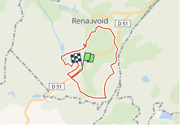
Tocht Stappen van 7 km beschikbaar op Grand Est, Vogezen, Renauvoid. Deze tocht wordt voorgesteld door BernardHumeau.

Beschrijving

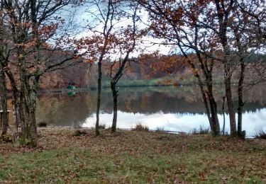
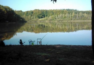
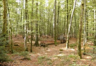
Petite rando facile de l'après midi à travers bois (feuillus et cônifères), un bon bol d'air dans les pâtures

Hoogteprofiel

Plaatsbepaling

Land:
France
Regio :
Grand Est
Departement/Provincie :
Vogezen
Gemeente :
Renauvoid
Locatie:
Unknown
Vertrek:(UTM)
305203 ; 5334426 (32U) N.

Wandeltochten in de omgeving

Tocht Stappen Chaumousey - Bouzey, côté abbaye  - Photo
Stappen
triburemy

Stappen

Medium
Chaumousey, Grand Est, Vogezen, France
6,1 km | 7,5 km-effort
1h 40min
Ja
Tocht Stappen Épinal - humbertois les ,2lacs - Photo
Stappen
BernardHumeau

Stappen

Medium
Épinal, Grand Est, Vogezen, France
7,3 km | 8,9 km-effort
1h 55min
Ja
Tocht Stappen Chantraine - De Chantraine à Bouzey - Photo
Stappen
jeanclaude12

Stappen

Gemakkelijk
Chantraine, Grand Est, Vogezen, France
14,6 km | 18,2 km-effort
3h 47min
Ja
Tocht Stappen Sanchey - A la Découverte de BOUZEY - Photo
Stappen
jeanclaude12

Stappen

Heel gemakkelijk
Sanchey, Grand Est, Vogezen, France
7,7 km | 9,3 km-effort
2h 4min
Ja
Tocht Stappen Épinal - Aux Champs de Damas - Photo
Stappen
jeanclaude12

Stappen

Gemakkelijk
(2)
Épinal, Grand Est, Vogezen, France
8,4 km | 10,3 km-effort
2h 17min
Ja
Tocht Stappen Sanchey - Circuit du tour du Lac de Bouzey - Photo
Stappen
tracegps

Stappen

Gemakkelijk
Sanchey, Grand Est, Vogezen, France
7 km | 8,5 km-effort
1h 40min
Ja
Tocht Mountainbike Uriménil - Espace VTT FFC Chemins du Pays d'Epinal, Coeur des Vosges - circuit n°99 - Chapuis Chantré - Photo
Mountainbike
tracegps

Mountainbike

Moeilijk
Uriménil, Grand Est, Vogezen, France
28 km | 36 km-effort
2h 15min
Ja
Tocht Mountainbike Épinal - Espace VTT FFC Chemins du Coeur des Vosges - circuit n°93 - Les champs de Damas - Photo
Mountainbike
tracegps

Mountainbike

Moeilijk
Épinal, Grand Est, Vogezen, France
18,9 km | 24 km-effort
1h 30min
Ja
Tocht Mountainbike Chaumousey - Espace VTT FFC Chemins du Coeur des Vosges - circuit n°87 - Circuit de l'Abbaye - Photo
Mountainbike
tracegps

Mountainbike

Medium
(1)
Chaumousey, Grand Est, Vogezen, France
11,7 km | 14,8 km-effort
1h 0min
Ja


Sluiten
Mijn abonnementen