


Les Vacheries de Valdeblore

frizou83
Gebruiker
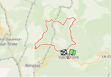

Lengte
15,9 km

Max. hoogte
2119 m

Positief hoogteverschil
1331 m
Km-Effort
34 km

Min. hoogte
996 m

Negatief hoogteverschil
1339 m
Boucle
Ja
Datum van aanmaak :
2020-02-20 22:01:58.403
Laatste wijziging :
2020-02-20 22:05:31.068
3h39
Moeilijkheid : Moeilijk

Gratisgps-wandelapplicatie
 SityTrail
IGN / Geografische instituten
SityTrail Plus
De wereld gaat voor u open
Over ons
Tocht Stappen van 15,9 km beschikbaar op Provence-Alpes-Côte d'Azur, Alpes-Maritimes, Valdeblore. Deze tocht wordt voorgesteld door frizou83.
Plaatsbepaling
Land:
France
Regio :
Provence-Alpes-Côte d'Azur
Departement/Provincie :
Alpes-Maritimes
Gemeente :
Valdeblore
Locatie:
Unknown
Vertrek:(Dec)
Vertrek:(UTM)
353548 ; 4881169 (32T) N.
Opmerkingen