


Villeneuve-lès-Avignon

mthomas30
Gebruiker
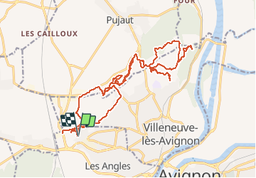

Lengte
27 km

Max. hoogte
171 m

Positief hoogteverschil
510 m
Km-Effort
34 km

Min. hoogte
49 m

Negatief hoogteverschil
510 m
Boucle
Ja
Datum van aanmaak :
2020-02-23 07:55:23.786
Laatste wijziging :
2020-02-23 11:01:15.164
3h05
Moeilijkheid : Moeilijk

Gratisgps-wandelapplicatie
 SityTrail
IGN / Geografische instituten
SityTrail Plus
De wereld gaat voor u open
Over ons
Tocht Mountainbike van 27 km beschikbaar op Occitanië, Gard, Les Angles. Deze tocht wordt voorgesteld door mthomas30.
Plaatsbepaling
Land:
France
Regio :
Occitanië
Departement/Provincie :
Gard
Gemeente :
Les Angles
Locatie:
Unknown
Vertrek:(Dec)
Vertrek:(UTM)
640574 ; 4869236 (31T) N.
Opmerkingen