Tocht Stappen Perros-Guirec - Les sentiers de Ploumanac'h - Perros-Guirec - Photo

Les sentiers de Ploumanac'h - Perros-Guirec

 LeonEvain
LeonEvain

Gebruiker

© OpenStreetMap contributors
Lengte
Lengte
8,6 km
Max. hoogte
Max. hoogte
64 m
Positief hoogteverschil
123 m
Km-Effort
Km-Effort  
10,2 km
Min. hoogte
Min. hoogte
1 m
Negatief hoogteverschil
120 m
Boucle
Boucle
Ja
Datum van aanmaak :
2020-02-27 08:58:03.648
Laatste wijziging :
2020-02-27 08:59:20.654

(0 Bericht)

Stappen
Stappen
2h13
Moeilijkheid : Medium

Scan deze QR-code om de tocht te openen in de SityTrail-applicatie

Gratisgps-wandelapplicatie

Logo SityTrail SityTrail

IGN / Geografische instituten

SityTrail uit de App Store downloaden SityTrail uit Google Play downloaden

Logo SityTrail SityTrail World

De wereld gaat voor u open

SityTrail uit de App Store downloaden SityTrail uit Google Play downloaden SityTrail op Huawei AppGallery downloaden

Over ons

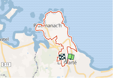
Tocht Stappen van 8,6 km beschikbaar op Bretagne, Côtes-d'Armor, Perros-Guirec. Deze tocht wordt voorgesteld door LeonEvain.

Beschrijving

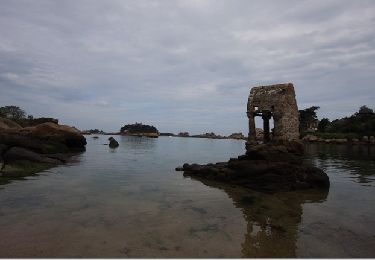
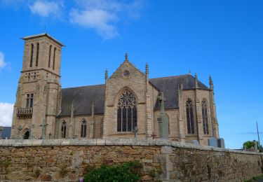
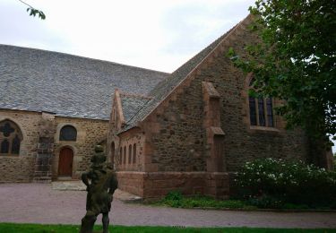
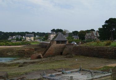
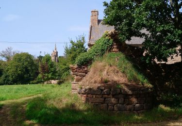
Parsemée de nombreux patrimoines historiques et maritimes, cette balade déroule un paysage unique au milieu d’amas de granits roses aux formes imposantes et étonnantes. Balisage : jaune. Retrouvez cet itinéraire dans le topo-guide ® D022 "Les Côtes-d'Armor… à pied" PR N°07. En vente en librairie, dans les offices de tourisme en Bretagne et sur www.ffrandonnee.fr.

Hoogteprofiel

POI's

POI Perros-Guirec - Anse de Pors-Rolland - Photo
LeonEvain
PERROS-GUIREC 
POI Perros-Guirec - Phare de Ploumanac'h (Mean Ruz) - Photo
LeonEvain
POI Perros-Guirec - Plage Saint-Guirec - Photo
LeonEvain
PERROS-GUIREC 
POI Perros-Guirec - Parc des sculptures Christian Gad et Daniel Chhe - Photo
LeonEvain
POI Perros-Guirec - Chapelle de La Clarté - Photo
LeonEvain
PERROS-GUIREC 

Plaatsbepaling

Land:
France
Regio :
Bretagne
Departement/Provincie :
Côtes-d'Armor
Gemeente :
Perros-Guirec
Locatie:
Unknown
Vertrek:(UTM)
465215 ; 5407318 (30U) N.

Wandeltochten in de omgeving

Tocht Stappen Perros-Guirec - la côte de granit rose à Ploumanach - Photo
Stappen
GUIDE
amiral13

Stappen

Heel gemakkelijk
(2)
Perros-Guirec, Bretagne, Côtes-d'Armor, France
6 km | 6,9 km-effort
2h 38min
Ja
Tocht Stappen Perros-Guirec - Les sentiers de Ploumanac'h - Photo
Stappen
tracegps

Stappen

Medium
(1)
Perros-Guirec, Bretagne, Côtes-d'Armor, France
10,3 km | 12 km-effort
3h 0min
Ja
Tocht Stappen Trégastel - GR34-EtapeIII-J05 - Photo
Stappen
JMCMoreau

Stappen

Gemakkelijk
(1)
Trégastel, Bretagne, Côtes-d'Armor, France
19,2 km | 21 km-effort
6h 30min
Neen
Tocht Stappen Perros-Guirec - Découverte de la Côte de Granit Rose - Photo
Stappen
GUIDE
pascalou73

Stappen

Gemakkelijk
Perros-Guirec, Bretagne, Côtes-d'Armor, France
3,9 km | 4,5 km-effort
1h 1min
Neen
Tocht Stappen Louannec - Louannec - GR34 PR - 11.5km 185m 3h00 (40mn) - 2023 09 14 - Photo
Stappen
Orcal37

Stappen

Moeilijk
Louannec, Bretagne, Côtes-d'Armor, France
11,5 km | 13,9 km-effort
3h 0min
Ja
Tocht Stappen Perros-Guirec - Perros-Guirec - GR34 - 11.1km 185m 2h50 - 2023 09 08 - Photo
Stappen
Orcal37

Stappen

Medium
Perros-Guirec, Bretagne, Côtes-d'Armor, France
11,1 km | 13,6 km-effort
2h 50min
Ja
Tocht Stappen Trégastel - Trégastel - GR34 Ploumanac'h Kasino de Perros-Guirec - 11.7km 200m 2h55 (50mn) - 2023 09 08 - Photo
Stappen
Orcal37

Stappen

Medium
Trégastel, Bretagne, Côtes-d'Armor, France
11,7 km | 14,4 km-effort
2h 55min
Ja
Tocht Stappen Trégastel - Trégastel - GR34 Île Renote Moulin à marée Chapelle de Gorgon - 13.8km 100m 3h35 - 2023 09 07 - Photo
Stappen
Orcal37

Stappen

Moeilijk
(1)
Trégastel, Bretagne, Côtes-d'Armor, France
13,8 km | 15,1 km-effort
3h 35min
Ja
Tocht Stappen Pleumeur-Bodou - Pleumeur-Bodou - GR34 Chapelle Saint-Samson - 7.7km 60m 1h55 - 2023 09 06 - Photo
Stappen
Orcal37

Stappen

Medium
Pleumeur-Bodou, Bretagne, Côtes-d'Armor, France
7,7 km | 8,5 km-effort
1h 55min
Ja


Sluiten
Mijn abonnementen