


8409335-SEMI 2019

funkady
Gebruiker
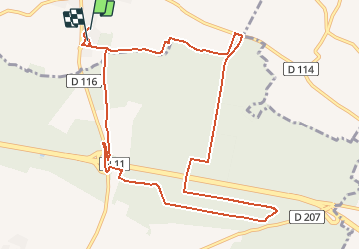

Lengte
11,7 km

Max. hoogte
51 m

Positief hoogteverschil
82 m
Km-Effort
12,8 km

Min. hoogte
26 m

Negatief hoogteverschil
76 m
Boucle
Ja
Datum van aanmaak :
2020-02-28 10:04:31.541
Laatste wijziging :
2020-02-28 10:19:48.642
1h20
Moeilijkheid : Heel gemakkelijk

Gratisgps-wandelapplicatie
 SityTrail
IGN / Geografische instituten
SityTrail Plus
De wereld gaat voor u open
Over ons
Tocht Trail van 11,7 km beschikbaar op Nieuw-Aquitanië, Charente-Maritime, Courçon. Deze tocht wordt voorgesteld door funkady.
Plaatsbepaling
Land:
France
Regio :
Nieuw-Aquitanië
Departement/Provincie :
Charente-Maritime
Gemeente :
Courçon
Locatie:
Unknown
Vertrek:(Dec)
Vertrek:(UTM)
668703 ; 5122746 (30T) N.
Opmerkingen