


La Charmouthienne_boucle_Saint Rémy_17km_2020-03-01

bernardcollignon
Gebruiker
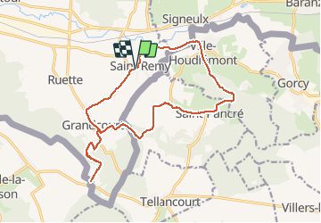

Lengte
16,7 km

Max. hoogte
401 m

Positief hoogteverschil
499 m
Km-Effort
23 km

Min. hoogte
222 m

Negatief hoogteverschil
499 m
Boucle
Ja
Datum van aanmaak :
2020-03-01 12:36:06.556
Laatste wijziging :
2021-03-09 18:53:35.47
3h55
Moeilijkheid : Heel gemakkelijk

Gratisgps-wandelapplicatie
 SityTrail
IGN / Geografische instituten
SityTrail Plus
De wereld gaat voor u open
Over ons
Tocht Stappen van 16,7 km beschikbaar op Wallonië, Luxemburg, Virton. Deze tocht wordt voorgesteld door bernardcollignon.
Plaatsbepaling
Land:
Belgium
Regio :
Wallonië
Departement/Provincie :
Luxemburg
Gemeente :
Virton
Locatie:
Bleid
Vertrek:(Dec)
Vertrek:(UTM)
689615 ; 5490810 (31U) N.
Opmerkingen