


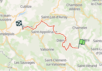
J3 - Monts du lyonnais - Ternand > Ronno

aeldin
Gebruiker

Lengte
19,8 km

Max. hoogte
880 m

Positief hoogteverschil
877 m
Km-Effort
31 km

Min. hoogte
437 m

Negatief hoogteverschil
772 m
Boucle
Neen
Datum van aanmaak :
2020-03-09 10:00:45.191
Laatste wijziging :
2020-06-15 17:23:49.333
--
Moeilijkheid : Heel gemakkelijk
--
Moeilijkheid : Heel gemakkelijk

Gratisgps-wandelapplicatie
 SityTrail
IGN / Geografische instituten
SityTrail Plus
De wereld gaat voor u open
Over ons
Tocht Vissen van 19,8 km beschikbaar op Auvergne-Rhône-Alpes, Rhône, Ternand. Deze tocht wordt voorgesteld door aeldin.

Plaatsbepaling
Land:
France
Regio :
Auvergne-Rhône-Alpes
Departement/Provincie :
Rhône
Gemeente :
Ternand
Locatie:
Unknown
Vertrek:(Dec)
Vertrek:(UTM)
616787 ; 5089369 (31T) N.
Opmerkingen