


2020 05 23 Bannstein 13km

staubalex
Gebruiker
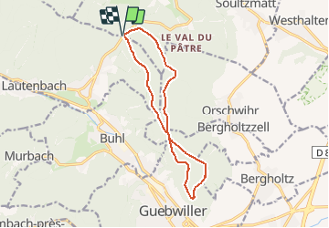

Lengte
12,4 km

Max. hoogte
590 m

Positief hoogteverschil
226 m
Km-Effort
15,4 km

Min. hoogte
490 m

Negatief hoogteverschil
229 m
Boucle
Ja
Datum van aanmaak :
2020-05-22 12:51:12.961
Laatste wijziging :
2020-06-13 11:00:12.79
1h00
Moeilijkheid : Gemakkelijk

Gratisgps-wandelapplicatie
 SityTrail
IGN / Geografische instituten
SityTrail Plus
De wereld gaat voor u open
Over ons
Tocht Andere activiteiten van 12,4 km beschikbaar op Grand Est, Haut-Rhin, Lautenbach. Deze tocht wordt voorgesteld door staubalex.
Plaatsbepaling
Land:
France
Regio :
Grand Est
Departement/Provincie :
Haut-Rhin
Gemeente :
Lautenbach
Locatie:
Unknown
Vertrek:(Dec)
Vertrek:(UTM)
365081 ; 5312730 (32T) N.
Opmerkingen