


Inghem 13Kms (Dén P 145m)

alain62rando
Gebruiker
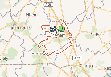

Lengte
12,9 km

Max. hoogte
93 m

Positief hoogteverschil
145 m
Km-Effort
14,8 km

Min. hoogte
42 m

Negatief hoogteverschil
145 m
Boucle
Ja
Datum van aanmaak :
2020-05-28 10:54:35.69
Laatste wijziging :
2020-05-31 04:23:01.913
3h15
Moeilijkheid : Medium

Gratisgps-wandelapplicatie
 SityTrail
IGN / Geografische instituten
SityTrail Plus
De wereld gaat voor u open
Over ons
Tocht Stappen van 12,9 km beschikbaar op Hauts-de-France, Pas-de-Calais, Bellinghem. Deze tocht wordt voorgesteld door alain62rando.
Beschrijving
Départ parking de l'église
Plaatsbepaling
Land:
France
Regio :
Hauts-de-France
Departement/Provincie :
Pas-de-Calais
Gemeente :
Bellinghem
Locatie:
Unknown
Vertrek:(Dec)
Vertrek:(UTM)
446445 ; 5613161 (31U) N.
Opmerkingen